

Superfund researcher takes samples of soil, air and water after hurricane
When Hurricane Florence made landfall along the North Carolina coast last month and the floodwaters began to rise, researchers in the Texas A&M Superfund Research Center knew what its residents could expect.
After all, the Superfund Research Center was established in September 2017 through funding from the National Institute of Environmental Health Sciences to evaluate the potential hazardous chemicals and chemical mixtures people may be exposed to as a result of these kinds of weather-related emergencies.
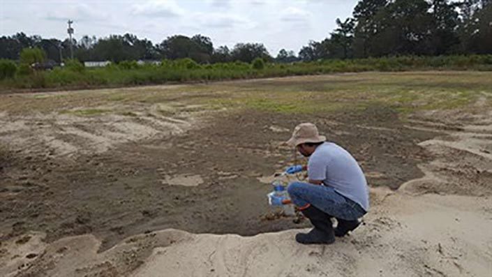
So, when given the opportunity to work with the Environmental Defense Fund and the Duke University Superfund Center, Superfund Research Center trainee and a third-year Texas A&M University toxicology doctoral student Gaston Casillas packed his bags in less than 24 hours for a six-day road trip that covered more than 1,000 miles across southeastern North Carolina.
There, Casillas, who had also worked in Houston as part of the Superfund Research Center response following Hurricane Harvey, spent approximately 12 hours each day with a mobile sampling unit and staff from the California-based Entanglement Technologies to real-time sampling of air and water. The group tested for benzene, toluene, ethylbenzene and xylene), as well as mercury in the water; volatile organic carbons in the air. Casillas also collected samples for future analyses of polycyclic aromatic hydrocarbons, pesticides, and metals in soil. Detailed maps of where the sampling occurred also were created.
The Entanglement staff and Casillas tested for these substances because researchers might expect to find them after accidents associated with flooding that damage storage ponds that store coal ash near old coal-fired power stations, said Jennifer Horney, a lead for the Superfund Research Center’s Community Engagement Core, who is also a faculty adviser for Casillas’ doctoral research project. Horney is an associate professor and head of the Department of Epidemiology and Biostatistics, School of Public Health.
“We were testing for those everywhere that had flooded in North Carolina. We went to the site where the coal ash was flooding before the dam broke and then to the Sutton Dam, which was a dam that separated recreationally from water that was connected with the coal ash plants,” Casillas said, adding that when the dam burst, they were able to follow the leak to the Cape Fear River. “We were live sampling the water from there when the first lock broke. Then a day-and-a-half later, the entire dam gave way and we returned and did some more surface water sampling on the Cape Fear River downstream from the plants.”