

Capturing flood data in real time: Proposed system would use artificial intelligence to analyze uploads of crowdsourced images
Flooding tops the list of natural hazards in the United States and many parts of the world.
However, in an age when reams of data about almost everything are readily available, real-time flooding data and analysis remains mostly a concept to first responders and the public, said Amir Behzadan, professor of construction science at Texas A&M University, who is developing a new system to collect, curate, and communicate this kind of data.
“When it comes to disaster impact, there are ‘data deserts’ — large areas in our communities in which we have very little information about the likelihood and extent of damage,” said Behzadan. “If this data is available, informed decisions can be made about immediate needs like search and rescue, as well as longer-term needs such as debris cleanup, economic recovery efforts, and where insurance companies can focus.”
Flood data gathering measures in many neighborhoods are very basic — if they exist at all, he said.
“There are flood gauges that are operated by the U.S. Geological Survey or local governments, but these have limited coverage and do not provide the full picture of how floodwaters move, especially in residential neighborhoods,” he said. “In Houston, some areas have buoys or gauges in rivers and creeks, but those only register conditions close by.”
More imprecise methods are used for large areas that don’t have these devices.
“As you move farther away from the small number of flood gathering devices we do have, you have to rely on modeling that uses hydrological equations and other mathematical techniques. Many times, these techniques are inaccurate because floodwaters’ movement depends on many variables, such as characteristics of the terrain it’s on, which affects how much water is being absorbed and how much of it runs off,” he said.
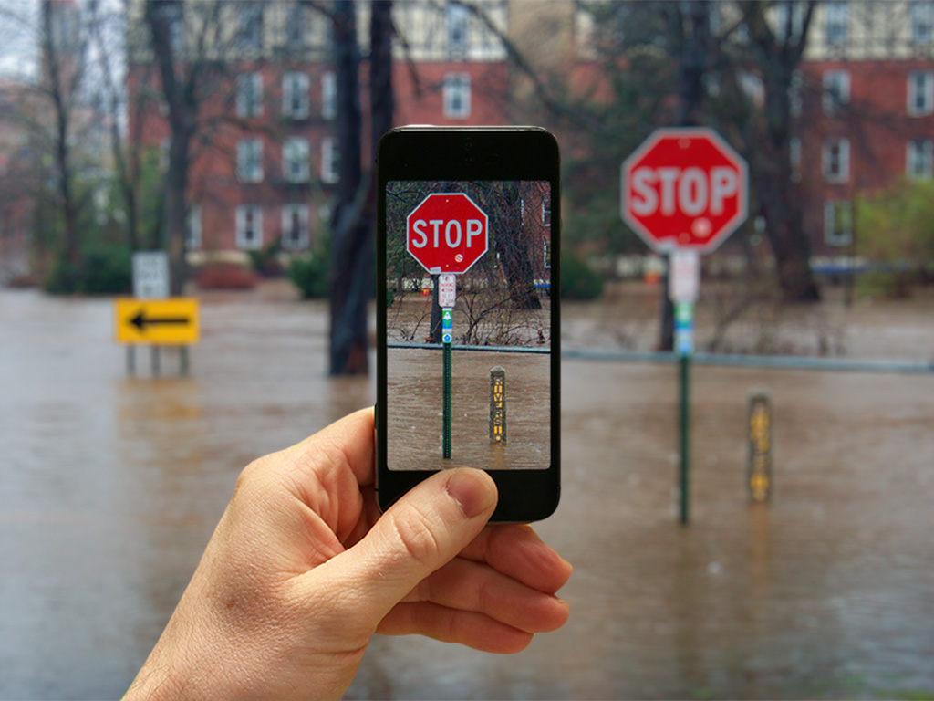
Behzadan, whose research aims to enhance the interface of artificial intelligence and the built environment, wondered how real-time flood data could be much more accurately gathered, analyzed, and widely distributed. As he pored over flood photos online, an idea came to him: what about an artificial intelligence-based solution that involved a standard unit of measurement that’s a common sight in neighborhoods everywhere — the stop sign?
“In a way, it’s really a very simple concept,” said Behzadan, who is heading the project with collaborators Michelle Meyer, director of the Hazard Reduction and Recovery Center, Courtney Thompson and Zhe Zhang, Texas A&M assistant professors of geography. The project is funded with a grant through the Texas Sea Grant Program from the U.S. Department of Commerce National Oceanic and Atmospheric Administration.
The system that Behzadan and his collaborators are developing works with data that can easily be captured in a flooded area.
When floodwaters strike, a resident would need merely to take a photo of the floodwaters at a stop sign with a mobile phone and upload it to an online crowdsourcing platform called BluPix that is also developed by the research team.
An artificial intelligence model that Behzadan and his collaborators are creating will compare the submitted floodwater photo with an existing Google Street View image of the same location, and, using the stop sign’s size as a measurement benchmark, estimate the depth of floodwaters in the location of the depicted stop sign.
Because the signs have a standardized 30” diameter, the pre- and post-flood photos don’t need to be from the exact same angle or time of day; the model will be able to recognize different angles and account for them as it provides the floodwater depth information.
“The application also provides a mapping interface so the floodwater information can be communicated in real time to the public, first response teams, and authorities,” said Behzadan.
He envisions the popularity of posting photos to social media sites as an aid to help dramatically improve flood data gathering.
“When you think about it, how many smartphones and tablets are out there, where people post photos on social media for the fun of it?” he asked. “Imagine these devices turning into flood data collection devices,” he said.